Archaeology and Ancient History
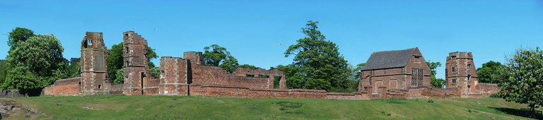
Bradgate Park Fieldschool Season 1 (2015)
Where did we dig?
Our first fieldwork season ran between the 8th June and the 16th July 2015. The focus was the medieval moated site located to the west of Bradgate House, the courtyard of the House and one of the outbuildings. A poster summarising the aims of the Season 1 fieldwork programme can be downloaded here. The preliminary findings are described below, although more will doubtless be revealed as our analyses proceed.
The moated site
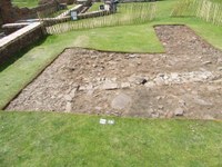
 To the west of Bradgate House lies a moated site approximately 50 metres square. Received wisdom is that this was the medieval keeper's lodge when the extent of the deer park was much smaller than it is now. Geophysical survey in 2014 revealed the presence of a large stone building in the centre of the platform (see right) with an apparent rectangular projection in the north face, a possible revetment wall within part of the southern and eastern banks and a circular low resistance feature.
Four trenches were opened up over the site: to investigate the moat (Trench 1); to examine different parts of the building and a possible pit or well (Trench 2 and Trench 4) and; to look at the bank close to the presumed entrance to the platform (Trench 3). These all had to be de-turfed (or rather de-brackened!) by hand before excavating down to the required level. A test pit excavated in April 2014 had already revealed that the stonework lay close beneath the ground surface, so we did not want to risk machine stripping.
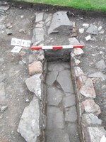
 The moat exists as an earthwork c.5m wide with a depth of c.1m; however, excavation showed that a further metre of sediment was present in the base of the ditch. At some point, a rather coarse stone drain was laid, presumably to improve water flow; unfortunately, there were few dateable finds from this feature. Examination of the bank in Trench 3 found that this did not contain a revetment wall, but there were hints of rubble consolidation, which probably explains the high resolution linear feature observed in the resistivity survey.
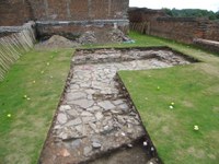
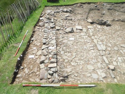
 Trenches 2 and 4 explored the interior and exterior of the central building. Trench 2 encompassed the northern wall, including the northern projection, the north-eastern interior of the building and also an exterior area north of the structure. Trench 4 focused on the south-western part of the building and the area beyond. Initial excavation of both trenches revealed a mass of stone and slate rubble, particularly concentrated over the rectangular projection. Careful removal of the rubble layers revealed stone wall lines, although these differed in width and construction. For example, towards the eastern end of the building the wall was only 0.40m wide, however, it was a much more substantial 0.70m around the rectangular extension.
 Padstones, which typically spanned the width of the wall, were spaced at regular intervals and provided evidence that this was a cruck-framed building, with stone infill to the lower part of the wall. The main width of the building, as indicated by the distance between padstones, is 7m, while preliminary calculations suggest that the crucks were positioned approximately 4.0m apart. Initial impressions are that the building originally comprised three bays but was later enlarged. The purpose of the rectangular projection was the focus of much speculation (garderobe, stair tower, porch and window...), the weight of the evidence came down on the side of a fireplace. Reddening was noted on the surrounding stones (handily also indicating the former floor level) and copious charcoal was present in the deposits exposed within the hearth area. It is likely that the building would have had a central fireplace to start with. However, burning was identified at floor level on the eastern side, coinciding with the narrow walling, which indicates that a smoke bay, probably open to the rafters, would have been added at a later point (Neil Finn, pers, comm).
 Further evolution of the fireplace came with the addition of the rectangular projection, providing greater control of the fire. The position of the smoke bay and hearth also clearly denote the location of the hall within the building. The south west side of the building (seen in Trench 4) was also multi-phase. This was probably the service bay and appeared to have been extended to the west at least twice (which made the building less centrally positioned on the moated platform than it had started out). The roof of the building was clad in slates, apparently graded in size from large (up to 0.6m in length) towards the base to smaller near the top. Finds of tile among the rubble indicate that the apex was capped with green-glazed sandy ware ceramic ridge tile (probably Chilvers Coton).
A pit on the south-west side of the building was visible from on the geophysics and initially there were high hopes that this would turn out to be a well. However, excavation showed it to be a large but shallow feature. It contained several sherds of Roman greyware but appeared to be cut from high up in the stratigraphic sequence, indicating that it was not as old as first supposed. On the north side of the building a pottery-rich deposit, probably a spread of waste, in which only the inorganic component has survived. Unfortunately, bones were rarely preserved on the moated site, almost certainly due to the acidic nature of the soils and we are yet to discover how well environmental remains have survived. Pottery dated the activity on the site to the medieval period and there was no significant cross-over with the activity at Bradgate House. Two medieval coins were also recovered (one was Edward I).
Bradgate House
Trench 5 marks the first recorded archaeological excavation within the scheduled monument of Bradgate House (built between c.1490-1520). The trench was located within what has been interpreted as the original courtyard area of the house that was subsequently blocked with ancillary buildings when the main entrance moved from the front (south) side of the house (leading to Anstey). The trench targeted partially extant wall lines that continued as parch marks forming what appeared to be a rectangular building that is on a different alignment to the layout of Bradgate House. Previous reconstruction of the house ruins suggested that this building which connected to the porters lodge to the south. However, after a notably dry May a parch mark was identified on the south side of the building suggesting it was likely to return before joining the lodge.
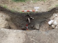
 Archaeological deposits were encountered directly below the thin turf and after the initial cleaning a considerable length of the eastern wall of the building was exposed which appeared to continue beneath a well constructed cobble path. This path appears to match up with further cobbling noted around the entranceway into the ruins. The majority of the trench appeared to be made up of a demolition/levelling deposit that did appear to be cut by a drain at the western end of the trench that was on a different alignment to the excavated building and Bradgate House. A further charcoal linear feature was also recorded on the eastern side of the wall (see picture below) that did not extend beyond the wall line.
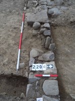
An initial slot was excavated across the path that suggested it was a modern construction and could be contemporary with the various fabricated walls around Bradgate House that are dated to the early 20th century. The removal of this path did revealed the southern return of the building, which measured 11m x 6m.
The upper mixed soil demolition/levelling deposit was removed within the internal area of the building that also exposed the western side of the wall. This overlaid a cleaner demolition deposit that was mortar rich, in which the majority of the finds were remarkably early with identified pottery dating between 1475-1550 and a notable absence of clay pipe. Other finds included fragments of a ?late medieval decorated glass vessel, a bone handled knife and glazed roof and floor tiles. A collection of five fragments of ?window mullions were also recorded near the eastern wall of the building. Both deposits did contain a reasonable quantity of Tudor brick although the exposed wall itself contained no brick within its facing or core. It appears that the courtyard area has been reduced/landscaped at a later date as there appears to be a total absence of material dating any later than the foundation period of Bradgate House.
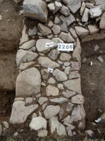
 The removal of these deposits revealed a remarkably well-preserved flagstone floor. The floor was mainly constructed out of large fragments of granite with smaller fragments of stone/slate used to infill the gaps, especially where the floor butted up against the wall. A rectangular space was recorded within the floor that ran roughly parallel with the western wall that has been interpreted as a beamslot for an internal partition. Removal of the soil within the beamslot indicated further layers below the flagstone floor consisting of clay and hints of mortar, perhaps suggesting earlier floor level are present beneath. A fragment of late medieval decorated floor tile was recovered from the base of the feature.
The only find associated with the flagstone floor was a late medieval horseshoe that was rusted to the floor, close to the western wall of the building. No other finds were recovered that have facilitated the interpretation of the buildings function. However, the presence of a drain built within the eastern wall that appears to flow into the building may provide further indication that the building may have been associated with housing animals with the drain facilitating the cleaning of the floor.
Excavation of the shallow demolition/levelling deposit to the east of the building revealed a series of different deposits. Within the north-east corner of the trench (on the highest ground) a further wall line was recorded that butted up against the eastern wall of the building running eastwards before returning northwards after c.1m. The continuation of this was recorded beyond the extent of the trench within a poorly defined parch mark suggesting the wall returned westwards to re-join the eastern wall of the building c. 6m to the north. Immediately south of the wall evidence of levelling was recorded. Here un-bonded (apparently unused) brick had been laid in a tight concentration. This whole area was overlain by clay which had notable quantities of large un-bonded granite sets within and on top of it. It is possible this deposit could be the remnants of the original courtyard surface of Bradgate House. South of this area further demolition layers were recorded and a ?robber cut was located on the line of the internal drain. This roughly matched up with the charcoal linear that was seen after the initial cleaning of the trench, perhaps suggesting the in-filling of some later slumping within the feature. Further to the south a sand deposit was revealed that sealed an area of metalled surface. This was located at a similar level to the flagstone floor and presumably represents the remains of an exterior yard surface associated with the building.
 The later drain was fully excavated within the western end of the trench, located beyond the western wall of the building. It was constructed out of a mix of stone and reused brick fragments with a well-built granite floor. It had originally been capped by large granite fragments that had collapsed into the structure. The floor sloped slightly towards the banqueting hall of Bradgate House, perhaps suggesting it was using the cellar as a soak away.
The later drain truncated a garden soil that overlaid an earlier drain. The drain appeared to respect the western wall of the building, perhaps cutting clays associated with construction cut of the wall. This drain was not excavated but is likely to date to an early phase of Bradgate House
In summary, our first investigation into the scheduled area of Bradgate House was both interesting and rewarding, even if actual function of the building remains uncertain. The pottery recovered from the demolition levels within the building dates to 1475-1550, encompassing the period of the construction of Bradgate House. This was surprising given the shallow depth of the archaeology, clearly indicating the deposits had been re-exposed through later ground reduction. The building may relate to the construction phase but it seems unlikely given the late medieval domestic material recovered as well as the fabric of the building itself, that appears too well constructed for a temporary structure. The most likely interpretation is that the building (or more likely a complex of buildings) was present on the site prior to the construction of Bradgate House. In this scenario the building remains in use during the construction of Bradgate House, almost as though the house was being built around its perimeter. Then the building was demolished at some point during the construction phase in order to create the courtyard.
Outbuildings
A substantial building was constructed on a platform to the immediate south of Bradgate House and features in the 1746 estate map drawn by Nicholas Kiddiar; however, its function and construction date were unknown: the aim of the excavation in trench 6 was to establish its date and function.
Turf and topsoil was removed that revealed two linear slate drains that criss-crossed the trench, partially truncating lower archaeological deposits and probably recent in date. A wall line was recorded running east-west along the southern edge of the trench, returning northwards for c.2m in the south-west corner of the trench. To the north of the wall an internal cobbled stone floor was exposed although this did not extend along the complete length of the wall. The floor contained parallel lines of larger stones that were slightly raised above the floor on its northern side, acting as a shallow drain. The drain ended c.2.5m east of the west wall where two larger stones combined with the line of further large uneven stones that ran perpendicular to the south wall. Beyond this line further truncated flooring was recorded but it appeared to be of a poorer build. Although not definitive it does suggests that building was extended on its western side, beyond the line of the original drain.
 A shallow robber trench was recorded that continued the line of the ?later western wall and a large in-situ stone was exposed c.5.5m from the south-west corner of the building that marked the north-west corner of the building. The northern side of the building consisted entirely of a shallow robber trench that had become in-filled with soil that had silted in from the northern side of the wall. This finds rich soil appears to have accumulated against the northern side of the wall during the lifetime of the building and date from the late 17th century onwards. The soil directly overlaid a rough, irregular stone deposit that is either the remnants of a surface or the terracing material for Bradgate House. The robber trench suggested that the building has been partially cut into this deposit to create a flat platform. The projected dimensions of the building measured c.20m x c.6m, forming a long rectangular structure.
To the south and west of the building further cobbling was exposed. Close to the south-west corner of the building clear cambering was recorded that included a shallow drain the ran diagonally away from the building. Initially it was assumed this was a contemporary external surface associated with the building. However evaluative slots proved that the surface continues beneath a layer of silt located underneath both phases of internal flooring. The building thus postdates a large surface of unknown function, date and extent that appears to have become colluviated prior to the construction of the building although it is possible the surface was reused externally. Further work is required to better understand this phasing but the colluviation, but may relate to one of the periods when Bradgate House lay largely unoccupied, such as after the Lady Jane Grey affair.
On the western side of the building a large sub-circular dump of building material was recorded extending beyond the western side of the trench. It consisted of a layer of bricks overlying a thick dump of rendering made out of gypsum. It is not known for certain were this material has come but it is likely to have come from Bradgate House.
In summary, the building probably dates to the late 17th century and could be attributable to the visit of William III in 1696. Documentary sources suggest stables for 100 horses were erected to accommodate the party that were constructed outside the house over a very short period of time. A similar style of narrow building dating from the same period is still present at Godolphin House in Cornwall which has been interpreted as a building for housing carriages and tethering animals. Again some further work is required next year in order to locate the entranceway and gain better understanding of the phasing of the earlier surfaces.