International Ocean Discovery Program
Expedition 343: Japan Trench Fast Drilling Project (JFAST)
 April – May 2012
The main goal of the JFAST project was to understand the very large fault slip that occurred on the shallow portion of the subuction zone during the 2011 Tohoku earthquake. This large slip of 30 to 50 metres was the main source of the devastating tsunami that caused so much damage and loss of lives along the northeast coast of Honshu, Japan. In order to understand how the fault moved with such large displacement in this region, the JFAST project had two main objectives. The first was to sample the fault in order to analyse the physical properties of the fault zone. The second was to make temperature measurements to estimate the frictional stress during the earthquake.
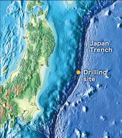
The drilling site was in the ocean area east of the Oshika Peninsula, just west of the axis of the Japan Trench. Two boreholes were drilled at a single location; the first hole was dedicated to collecting downhole geophysical data to determine in situ stress and locate the fault zone, and the second hole was dedicated to retrieving core samples from across the Tohoku earthquake slip surface. Each hole was completed with the deployment of an observatory that comprised of a suite of temperature and pressure sensors. Observatory data from both boreholes will be retrieved by the Japan Agency for Marine Earth Science and Technology’s (JAMSTEC) Remotely Operated Vehicle (ROV) KAIKO 7000II.
- NERC grant number: NE/K00123X/1
- IODP Expedition 343
Publications
- Lin, W., Conin, M., Moore, J. C., Chester, F. M., Nakamura, Y., Mori, J. J., Anderson, L., Eguchi, N. and Expedition 343 scientists, 2013. Stress state in the largest displacement area of the 2011 Tohokuoki Earthquake. Science, 339, 687-690. doi: 10.1126/science.1229379