Space Park Leicester’s new satellite system monitoring real-time imagery of Hurricane Beryl
In a significant breakthrough for real-time environmental monitoring and disaster response, Space Park Leicester has successfully utilised its advanced satellite system to capture near real-time images of Hurricane Beryl.
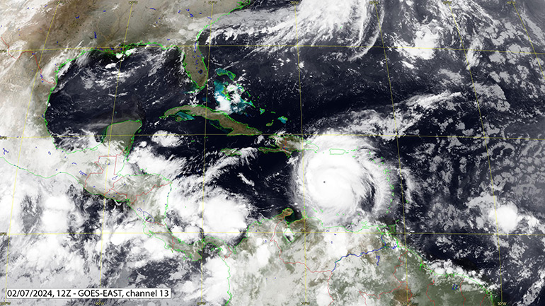
Hurricane Beryl has ripped across the Caribbean with winds of 240km/h (150mph) tearing roofs from buildings, uprooting trees and devastating the islands in its path. The hurricane peaked at Category 5 on the Saffir-Simpson scale on July 2. Indeed, Beryl is the earliest Category 5 system ever recorded, since the scale was first introduced in 1974.
This cutting-edge capability, part of a larger initiative funded by UK Research and Innovation’s (UKRI) World Class Labs scheme, demonstrates the potential of satellite technology to provide critical insights and support during natural disasters.
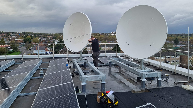
The University of Leicester’s space and Earth observation hub, Space Park Leicester, is now equipped with a state-of-the-art satellite data acquisition system known as EUMETCast.
This system, a collaboration with the National Centre for Earth Observation (NCEO), leverages two new 1.8 metre dishes mounted on the facility’s roof to receive data from the Hotbird-13G satellite.
Dr David Moore, NCEO scientist, School of Physics and Astronomy, University of Leicester said: “The EUMETCast system is an integral part of the European Organisation for the Exploitation of Meteorological Satellites (EUMETSAT) network, providing a continuous stream of meteorological and climate data using standard Digital Video Broadcast (DVB) technology.”
The received data is processed by two high-performance workstations that decrypt and perform initial analyses. A third workstation, dedicated to visualisation, converts the data into interactive, user-friendly images and animations, offering dynamic visual insights into weather patterns and atmospheric conditions.
David added: “The EUMETCast system excels in delivering data within a short timeframe, often within three hours and in many cases within just one hour of collection. This rapid data acquisition and processing are pivotal for responding to dynamic environmental events.
“During Hurricane Beryl, Space Park Leicester’s satellites dishes are receiving timely imagery, enabling detailed monitoring and analysis of the storm’s development and trajectory.”
These capabilities are further enhanced by Space Park Leicester’s access to a diverse array of geostationary and low-Earth orbit satellites. Geostationary satellites provide comprehensive coverage and frequent updates, making them ideal for creating full-disk movies every 10-15 minutes.
Low Earth orbit satellites such as Sentinel-3, Sentinel-5P, and MetOp offer high-resolution, detailed observations crucial for tracking specific atmospheric changes and surface conditions.
The imagery and data acquired from EUMETCast at Space Park Leicester will provide invaluable support for global disaster response. By analysing satellite data in near real-time, experts at the NCEO can rapidly assess the scale and impact of natural disasters.
David said: “Data acquired from EUMETCast will be used for ocean monitoring, atmospheric composition and land applications, allowing scientists across NCEO institutes to provide a rapid analysis and response to events such as hurricanes, wildfires and floods.
For instance, during the March 2019 flooding in Mozambique, NCEO specialists provided critical insights to the UK Government Department for International Development (DFID), facilitating an informed and effective response.
The vision for Space Park Leicester’s satellite system extends beyond monitoring. The data and visualisations produced aim to guide governmental and international agencies in deploying resources and relief efforts more effectively after natural disasters.
The NCEO-ASSESS facility, housed at Space Park Leicester, is developing responsive systems to ensure timely analysis and support during emergencies. As these systems evolve, they will play a crucial role in disaster preparedness and management on a global scale.