A team of UK scientists have been monitoring the devastating smoke plume in Canada and North America
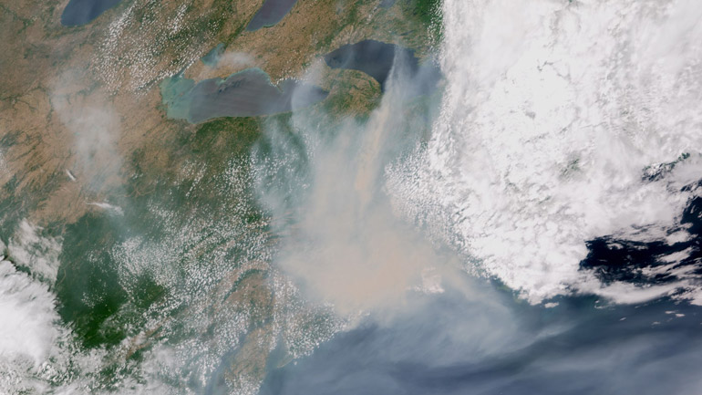
Smoke plume over USA. Credit: Simon Proud / RAL Space / NCEO / NOAA
The National Centre for Earth Observation (NCEO) is bringing a team together to support data images for the public and expert insight through its headquarters at Space Park Leicester. Scientists based at the University of Leicester, King's College London and RAL Space have been monitoring the devastating plume of smoke which has travelled from Canada to parts of the North American east coast.
Severe wildfires in Canada are producing huge quantities of smoke and gas that have been blown by the wind across Canada, the USA and out into the Atlantic. On Wednesday in New York, the smoke caused the sky to turn orange and the worst recorded air quality in two decades.
Professor John Remedios, NCEO Director at the University of Leicester said: “Satellites are giving us compelling views of the nature of these truly continental-scale impacts on people’s everyday lives. The current situation is apparent to all but our research also shows elevated gaseous pollutants will have been emitted as well as smoke, impacting people directly but also changing the nature of the atmosphere right across the mid and high latitudes of the northern hemisphere. We are stepping up our monitoring efforts as a result of the current situation.”
Professor Martin Wooster, NCEO Divisional Director at King's College London said: "Wildfires are a natural part of Earth's environmental system, and places such as the boreal forests of North America have evolved to host fire as part of their ecosystem function. Fire activity in such regions varies in response to changes in climate and human behaviour, and there is also simple natural variability as well. Climate change is generally proceeding at a faster rate at higher latitudes, and there is good evidence that for example the length of the fire season in parts of Canada has widened with a resulting increase in the amount of fire occurring."
It has been acknowledged that this year is on track to be the most extreme ever Canadian fire season. Although the fire season will not end until the fall (Autumn) Canada has apparently reported 2133 fires so far this year, whereas over the last decade there has been an average of 1,726 wildfires up to the start of June.
Scientists at RAL Space NCEO have been tracking the pollution using weather satellite images coupled to advanced algorithms that estimate the concentration of gases and smoke in the atmosphere. The RAL Space IMS tool, using data from EUMETSAT’s MetOp-B satellite, highlighted a large plume of Carbon Monoxide on 6 June that stretched from Ottawa, Canada to Washington and Boston, USA.
Dr Simon Proud, NCEO scientist at RAL Space, said: “Thick smoke and carbon monoxide, a gas produced by the fires, are being blown from Canada across the North-Eastern United States - highlighted by the dreadful air quality seen in New York on 7th June. Using images from weather satellites, we are tracking the smoke and gases as they continue to be produced by fires that are still burning. Unfortunately, air quality is still bad across much of the Eastern US and will remain so for several more days at least.”
Professor Martin Wooster, Divisional Director at NCEO and Professor of Earth Observation Science at King's College London is in the final stages of planning an airborne science campaign to Canada later in the year, exactly to investigate boreal wildfires further in collaboration with the Canadian forest service. One of the aims of the campaign is to help evaluate the accuracy of the information now being delivered on fires worldwide from Europe's Sentinel-3 satellite, which is aimed at rapidly identifying and mapping fires as well as estimating the amount of material they are putting into the atmosphere that can cause exactly the types of air quality problems we are seeing now in North America.