Leicester geoscientist makes expedition to the site of Japanese earthquake
A University of Leicester geoscientist is joining the crew of a science vessel investigating the site of the 2011 Tohoku earthquake in Japan.
The scientists will investigate the causes of the earthquake and will drill hundreds of metres under the seafloor, nearly seven kilometres below the ocean.
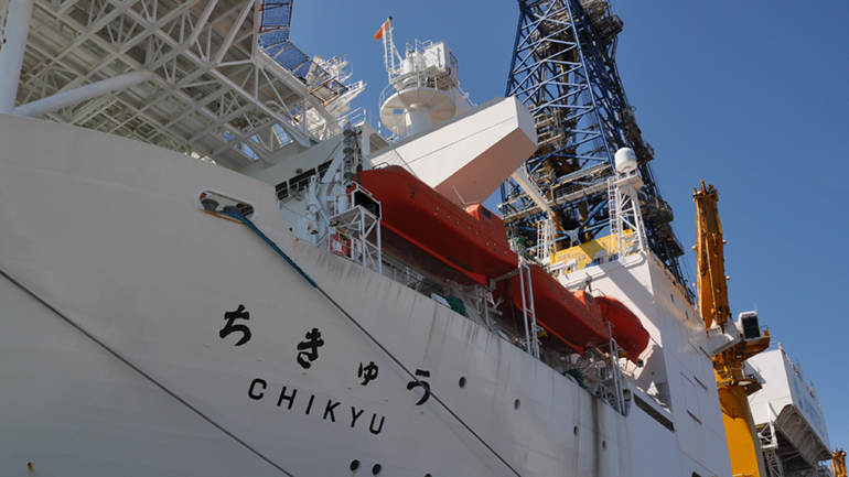
International Ocean Discovery Program (IODP) Expedition 405 ‘Tracking Tsunamigenic Slip Across the Japan Trench (JTRACK)’ will be conducted in the Japan Trench, where the devastating Tohoku earthquake occurred in 2011. The Deep-Sea Scientific Drilling Vessel Chikyu will operate here until early December.
The expedition is building on previous IODP Expedition 343 ‘Japan Trench Fast Drilling Project (JFAST)’ that took place in 2012. This year, the team will collect core samples, measure physical properties down the drill hole, and install an observatory.
Dr Marisa Rydzy from the School of Geography, Geology and the Environment at the University of Leicester joins IODP Expedition 405 as one of three logging staff scientists. They form part of the operations team and are intermediaries between the offshore engineers who run the downhole logging tools and the scientists that use the data.
Her job involves assessing data quality and providing logging data files, so scientists can use them. She also supports the scientists who are new to downhole logging understand and implement the data.
Dr Rydzy said: “As a petrophysicist, I am thrilled to be part of a science project that is heavily focused on physical rock properties and of noted significance to the public. Almost everyone still remembers the 2011 Tohoku-oki earthquake that triggered a devastating tsunami. This tsunami cost tens of thousands of lives and brought about the infamous Fukushima nuclear disaster. The Chikyu will drill through the earthquake fault zone and collect data to better understand the mechanics of the incident and events just like it.
“Aside from the scientific importance, the expedition also represents an impressive technological feat. Not only will this expedition attempt to drill through the upper tectonic plate AND the subducting one underneath, it will do so at a water depth of nearly 7 kilometres. I mean, seriously, how cool is that?
The previous expedition in 2012 recovered a portion of the plate boundary materials. It revealed that the very low shear stress can be attributed to the abundance of weak clay and thermal pressurization effects, which can ease slip in the fault zone. The expedition also measured the heat generated by the earthquake.
Revisiting the research area of the previous expedition, the JTRACK expedition attempts to reveal the post-earthquake fault recovery process, the slip mechanism of shallow part of the plate boundary fault and the effect of the material properties of subduction zones on plate boundary faults. Drilling will take place at two sites. One drill site will cross the fault that slipped during the 2011 earthquake, and the other site will be on the subducting Pacific plate. At each site, the expedition will measure physical properties down the drill hole and collect samples. An observatory will be installed across the plate boundary fault to capture detailed changes in sub-seafloor temperatures.
IODP is an international scientific research cooperative project started in October 2013. By drilling deep below the ocean floors using drilling vessels provided by Japan (JAMSTEC DV Chikyu), the United States (JOIDES Resolution), and Europe (Mission-Specific Platforms), IODP promotes research aimed at elucidating the global environmental change, the Earth’s internal structure and the biosphere within its crust.
The University of Leicester has been involved in the International Ocean Discovery Program since the 1980s and participated in dozens of expeditions around the world. In 2023, Dr Rydzy joined fellow University of Leicester scientist Dr Andrew McIntyre on IODP Expedition 389 ‘Hawai’ian Drowned Reefs’, which succeeded in obtaining a high-resolution continuous record of environmental data from shallow-water corals off the coast of Hawai’i (USA) by coring fossil coral reefs.