Earth Observation research detects methane over Poland’s coal mines
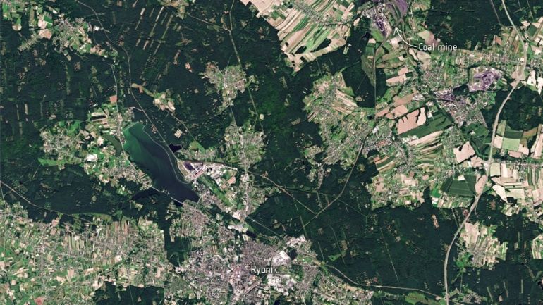
This Copernicus Sentinel-2 image shows Rybnik, located southwest of Katowice, with several coal mines visible in the nearby surroundings. Credit: Contains modified Copernicus Sentinel (2021), processed by ESA, CC BY-SA 3.0 IGO
Data from the Tropomi instrument onboard the Copernicus Sentinel-5P satellite has been used by Leicester-based Earth Observation experts to detect methane plumes over some of Europe’s largest methane-emitting coal mines.
Methane is an important greenhouse gas emitted from natural sources, such as wetlands, as well as human activities including agriculture, wastewater management and fossil-fuel production. Methane is the second most abundant anthropogenic greenhouse gas after carbon dioxide yet is more than 25 times as potent as carbon dioxide at trapping heat in the atmosphere.
It is important to track and manage fugitive methane emissions, gases that escape or leak unintentionally or through a controlled release from industrial processes, as significant gains can be achieved in limiting global temperature increase by curbing such emissions. It is therefore critical to implement policies aimed at reducing methane emissions as a key to combating climate change. This is particularly timely with more than 100 countries signing up to the Global Methane Pledge which aims to limit methane emissions by 30% by 2030, signed during the COP26 at Glasgow last year.
Methane emissions from coal mining
The coal mining industry contributes significantly to global methane emissions and is responsible for around 33% of all fossil fuel related emissions of methane from 2008 to 2017. Typically, for underground coal mines, large-scale ventilation systems are used to provide the flow of fresh air underground to help dilute gases such as methane, as well as help regulate the temperature for safe working conditions.
However, this ‘ventilation air methane’ ultimately ends up being released into the atmosphere, thereby acting as a source of fugitive methane.
According to the European Commission and the European Environment Agency, the top 10 largest methane emitting coal mines in Europe are in Poland. Collectively, these mines released around 282 kilo tonnes of methane into the atmosphere in 2020.
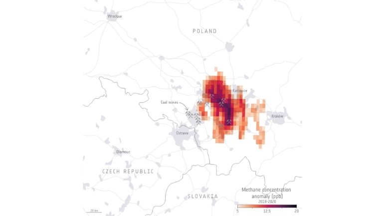
This map shows the averaged methane concentration anomalies detected by the Tropomi instrument on the Copernicus Sentinel-5P satellite from 2018 to 2020 over southern Poland. The pickaxes indicate the positions of the largest underground coal mines. Credit: ESA (contains modified Copernicus Sentinel (2018-20), processed by University of Leicester, CC BY-SA 3.0 IGO
Following methane observations from the European Space Agency (ESA)’s Copernicus Sentinel-5P satellite, we can now observe regions with enhanced methane concentrations from strong point sources all over the world. Satellite observations are a powerful tool for improving estimates of emission strength, seeing how they change over time and can also help detect previously unknown emission sources.
Scientists from the University of Leicester have used data – generated by the University of Bremen – from the Tropomi instrument onboard Sentinel-5P to observe methane concentrations associated with key mining regions across Poland and demonstrate whether the satellite can capture coal mining emissions.
The accumulated methane from the area pictured between 2018 and 2020 revealed that the largest methane concentrations were concentrated in the Upper Silesian Coal Basin, west of Krakow, a prominent mining region dominated by a cluster of underground coal mines.
Dr Harjinder Sembhi, Earth Observation Scientist at the University of Leicester, said: “As some of these mines are in very close proximity to each other, individual plumes are tricky to observe. However, we were able to detect averaged large-scale methane enhancements, approximately 20 parts per billion above background concentrations.”
Professor Hartmut Boesch is Divisional Director of the UK’s National Centre for Earth Observation (NCEO), hosted at Space Park Leicester, and Head of the Earth Observation Science Group at the University of Leicester. Professor Boesch added: “Despite some limitations in satellite data coverage, owing to clouds, we found that the regions of largest concentrations detected by Tropomi are consistent with the largest emitting mines in Poland as reported by the European Commission emission database.”
The NCEO, whose headquarters are hosted at Space Park Leicester, processes and analyses vast quantities of data generated by satellites, as well as by aircraft and ground-based assets to monitor and understand global and regional fire impacts.
To find out more about the NCEO’s work, visit nceo.ac.uk.