New satellite imagery reveals impact on urban landscape in wake of tragic earthquake
Satellite image ©2023 Maxar Technologies
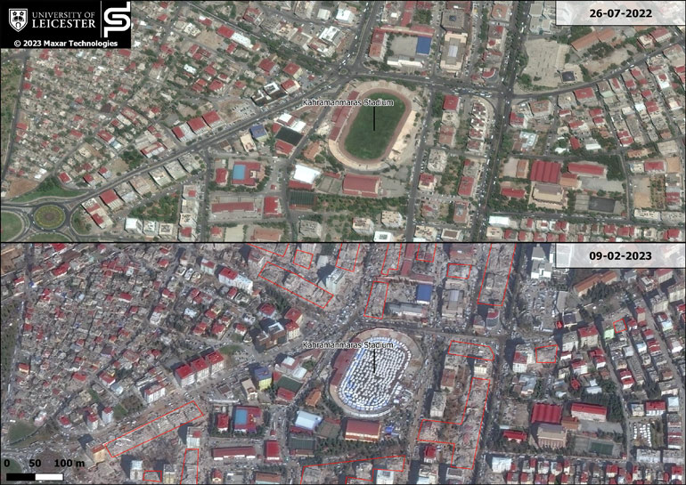
Satellite images of the city of Kahramanmaraş in Turkey taken before and after the recent devastating earthquake show the extent of its impact upon buildings and infrastructure.
The images have been released by a team of earth observation scientists at the University of Leicester to assist humanitarian efforts in the wake of the disaster. The scientists are also working with their counterparts at Karadeniz Technical University in Turkey on a study that aims to identify areas affected by the earthquake.
The earthquake has taken a devastating toll on life in Turkey and Syria, with reportedly over 44,000 lives lost and millions more left homeless.
Professor Kevin Tansey of the University of Leicester School of Geology, Geography and the Environment said: “The lives lost in the wake of the recent earthquake in Turkey and Syria are a tragedy felt across the world, and as the focus shifts towards recovery and providing aid, the availability of data plays a vital role in preventing further loss of life.
“Vast amounts of image data of the Earth’s surface are collected on a daily basis. When a natural disaster strikes, it is important to be able to download, process and disseminate information as quickly as possible. Working with both our local partners at Space Park Leicester and international collaborators in Turkey we can access arrays of time-series imagery and identify where change has taken place, in some cases using deep learning methods. ”
Dr Volkan Yilmaz, Associate Professor, Department of Geomatics Engineering at Karadeniz Technical University, noted: “We are working with European Copernicus Sentinel data to detect buildings that have been affected by the earthquake over large areas. Our main aim is to come up with a methodology using satellite imagery, which will also let us identify the damage in large-extent areas. The high resolution MAXAR imagery that the University of Leicester has access to will be used as a reference to evaluate the performance of our methodology.”
The images were acquired by WorldView-2, a high resolution satellite operated by the company MAXAR. Naif Aljehani, a current student on the University’s MSc in Satellite Data Science, read the imagery into an open source geospatial mapping software and used images before and after the earthquake struck to identify and label buildings that were affected.
The video compares an image of Kahramanmaraş, which is located near the epicentre of the earthquake, taken in July 2022 to one taken on 9 February 2023. It highlights the impact on the infrastructure after the earthquake took place. Where before there were buildings standing, casting shadows and occupying a regular shaped building footprint, in the 9 February imagery a visible change has taken place that can be associated with a collapse of buildings. The images also reveal the emergence of tents located in the Kahramanmaraş Stadium, providing evidence of a humanitarian effort in the area.
Professor Tansey adds: “The International community has a charter which instructs governments, through their respective space agencies, and private companies who operate satellite systems in space to co-ordinate the collection of image data and share that image data with aid agencies, governments and international agencies to help primarily with the assessment of the safety of accessing certain regions. This might be the availability of roads and other transport networks, to identify the scale of the damage, to assess the severity of damage, to prioritise aid and resources, and also to validate and ensure that a response is being co-ordinated and is happening.
“What this imagery shows you is the scale of the damage, which can support the humanitarian effort and later support the recovery effort.”
The University of Leicester is committed to supporting staff and students who have been affected by the recent earthquake in Turkey and Syria. It has reached out directly to support people in its community from these regions, and the Students’ Union has hosted a Red Cross fundraising drive for victims of the earthquake.